Mills and Millers at Eaton
The earliest evidence of milling at Eaton is a stone pestle which is dated from the neolithic period/early iron age.
Two Iron Age/Early Roman quern top stones were found in 1951 during ironstone quarrying to the North of Eaton. These are made of a much harder stone than the local ironstone and so would have been a valuable commodity. They worked much like the millstones in a mill with the top stone grinding against a lower bottom stone.

The first record of a specific miller is not until 1644 with the will of William Tinsley (or Tilsley) who died in 1661. William describes himself as miller Eaton. The Tinsley's appear to remain as millers with William's son, also William, describing himself as a miller in his will of 1685 and leaving his 'gears and flours' to his son James. The next mention of a miller in Eaton is in the 1740 will of John Needham so at some stage the mill has passed from management by the Tilsley’s to the Needham family.
By the late 18th Century there is much more evidence of milling at Eaton. In 1777 John Prior produced a map of Leicestershire on which all the mills, wind and water, are marked. The actually survey work was undertaken by Joseph Whyman, a former pupil of Prior, and was conducted between 1775 and 1777. This map shows three mills at Eaton. A watermill on the River Devon and two post mills; one in the fields opposite the watermill across the road to Branston and the other to the South of the village towards Green Lane. This third mill has been a bit of a mystery and so more research has been conducted to understand where exactly it was and what happened to it. More on this search, and the answer can be found here.

In 1770 Eaton’s Enclosures were carried out and the manuscript shows that the meetings were conducted at the house of Thomas Thorold ‘called or known by the sign of the millstone’. We know that Thomas Thorold was a miller and there is evidence that he was a millwright. In his will of 1784 he leaves his land and property to his son but his wife Elizabeth has free use and occupation of the windmill until her death.

Thomas is succeeded by his son Samuel Thorold who by 1793 has the post mill up for sale. It appears to still be up for sale a year later. It’s not clear if and when it’s sold but the post mill is replaced by a six story brick built tower mill in 1845, on land owned by the Duke of Rutland and under the management of Thomas Thorold, Samuel’s son. An 1843 advert for a journeyman miller gives a hint that the post mill must still be in place as it asks for applications to ‘Thomas Thorold and Sons, Eaton Mills’. This is referencing the water mill and windmill being managed together. This is reinforced in the 1851 will of Thomas Thorold;
‘I give and bequeath all that my Windmill standing on a piece of Land belonging to his Grace the Duke of Rutland with all the working Gear Implements and Effects belonging thereto standing near the Village of Eaton aforesaid unto my said Son George his Executors Administrators and Assigns And I humbly request his Grace the Duke of Rutland at my decease to admit my said Son George Tenant to the Water Mill as well as to the said Windmill and about twenty three Acres of Land now occupied therewith and my said Son Samuel to the Farm which I now occupy’.
It’s not clear exactly when the water mill ceased to grind corn. The 1884 Ordnance Survey map shows the mill marked as a cornmill with the sluices still evident. By the 1904 edition these have gone.

The brick tower mill was built by Challands of Bottesford and had 3 pairs of stones. This must have massively increased the efficiency and potential output of the mill. A 1912 newspaper article in the Grantham Journal quotes a Mr D Smart from Eaton, who worked for Thomas Thorold. Mr Smart said he ‘has known a waggon with three white horses to fetch ten quarters of wheat from Grantham one day and take it ground to Melton Mowbray the next.’
George Thorold inherits the management of the mills from his father Thomas. On his death in 1858 it passes to the management of his second wife Mary and his only child, from his first wife, Elizabeth. For a short while after the miller is named as Fanny Swain. It’s not clear on her connection to the family although George Thorold’s sister Mary did marry a Thomas Swain. Unfortunately there is nothing in the census records to show Fanny’s background.
Elizabeth ultimately takes on running the mills with her husband William Lee. William is listed as the miller in directories until his death in 1886. His son George Lee, although an apprentice miller when younger, becomes one of the village bakers.
At this point the mills are taken on by George Rowbotham, Eaton’s last miller. By 1891 he is only using the windmill for milling and the watermill has become his house.
In November 1910 disaster strikes and a storm damages the cap and rips off one of the sails. At this stage the Grantham Journal says there is little chance of restoration and this is not surprising given George is in his 70s. By May 1912 the tower is being demolished. George Rowbotham lives on at the watermill until the mid 1920s when he moves with his wife Fanny to Wymondham to live with his son.
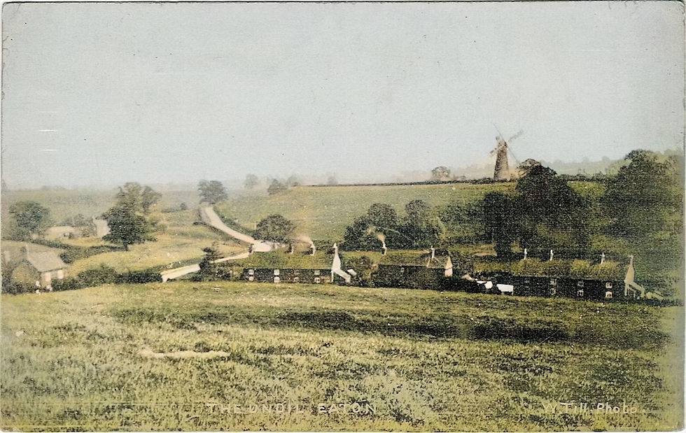
Eaton tower mill early 1900s with road to Branston on the left

Millhouse c 1950

Mill house c 1980
Eaton tower mill early 1900s with road to Branston on the left
The search for Eaton’s third mill… We know from the 1777 map that Eaton had a third mill, a post mill situated up on the north side of Green Lane and to the east of Waltham Lane. But where exactly was it and what happened to it? So began some detective work…. The Enclosures Act of 1770 refers to a provision for a road to an existing mill on land in the ownership of Thomas Morris: ‘Also a private horse carriage and drift road or way to begin at or about seventy seven yards from the South East corner of the Vicars allotment in lieu of tithes and to lead and go into through that part of the allotment of the said John Duke of Rutland in the Clay Field which lies between the said road leading from Eaton to Waltham and the allotment of the said Thomas Morris whereon there now stands a wind mill as and for a private carriage road to and from the said mill. ‘ Unfortunately the Enclosures Act does not have a supporting map and we are not 100% sure where the Vicars allotment was. Glebe Farm is perhaps a clue and this would align with the general location for the description and Prior’s 1777 map. The Enclosures awards Thomas Morris with a total of 29 perches of land bounded on all sides by land allotted to the Duke of Rutland (29 perches is just over 1/6th of an acre) and we know his allotment includes the existing site of the windmill. An online search of the records held at the Leicestershire Records Office showed some documents relating to a mill or mills at Eaton and at Scalford. And seeing the documents in person revealed a fascinating story…… It appears that the mill was originally located in Stonesby in the occupation of John Hornbuckle and was moved to its location in Eaton around 1745. An indenture dated 1766 suggests that it was erected on a parcel of land ‘there called the Clift and containing by estimation half an Acre or thereabouts’. The land at the time belonged to Thomas Wright but appears to have then been sold Andrew Meadows a grazier from ‘Cold Orton’ (presumably Cold Overton). In 1763 Andrew Meadows sells the leasehold for the mill and land to John Needham a miller of Eaton. However by Easter 1766 John Needham has not paid the £50 plus interest that is owed and Andrew Meadows seeks a writ of possession which is granted in September of the same year. At this time Andrew Meadows then sells the mill and at least part of the land to Thomas Morris, miller from Scalford for £70. In a plot twist, just 11 years later Thomas Morris leases the mill to John Needham. We don’t know what happens after that. John Needham dies in 1803 and Thomas Morris dies in 1818 at the mill in Scalford. It seems likely that it is moved or demolished at around the time of John Needham’s death because it is not evident on maps from 1810. But where exactly was it situated? We know that it was originally a parcel of land of about half an acre but by the enclosures of 1770 this is just 1/6th of an acre. It lies down an intended trackway which starts about 77 yds from the South East corner of the vicars allotment for tithes and that the trackway is about 200 yards long but until we can pinpoint where this track starts we can't be sure of the exact location.....still more research is needed!